
How ALTA Surveys Enhance CRE Due Diligence
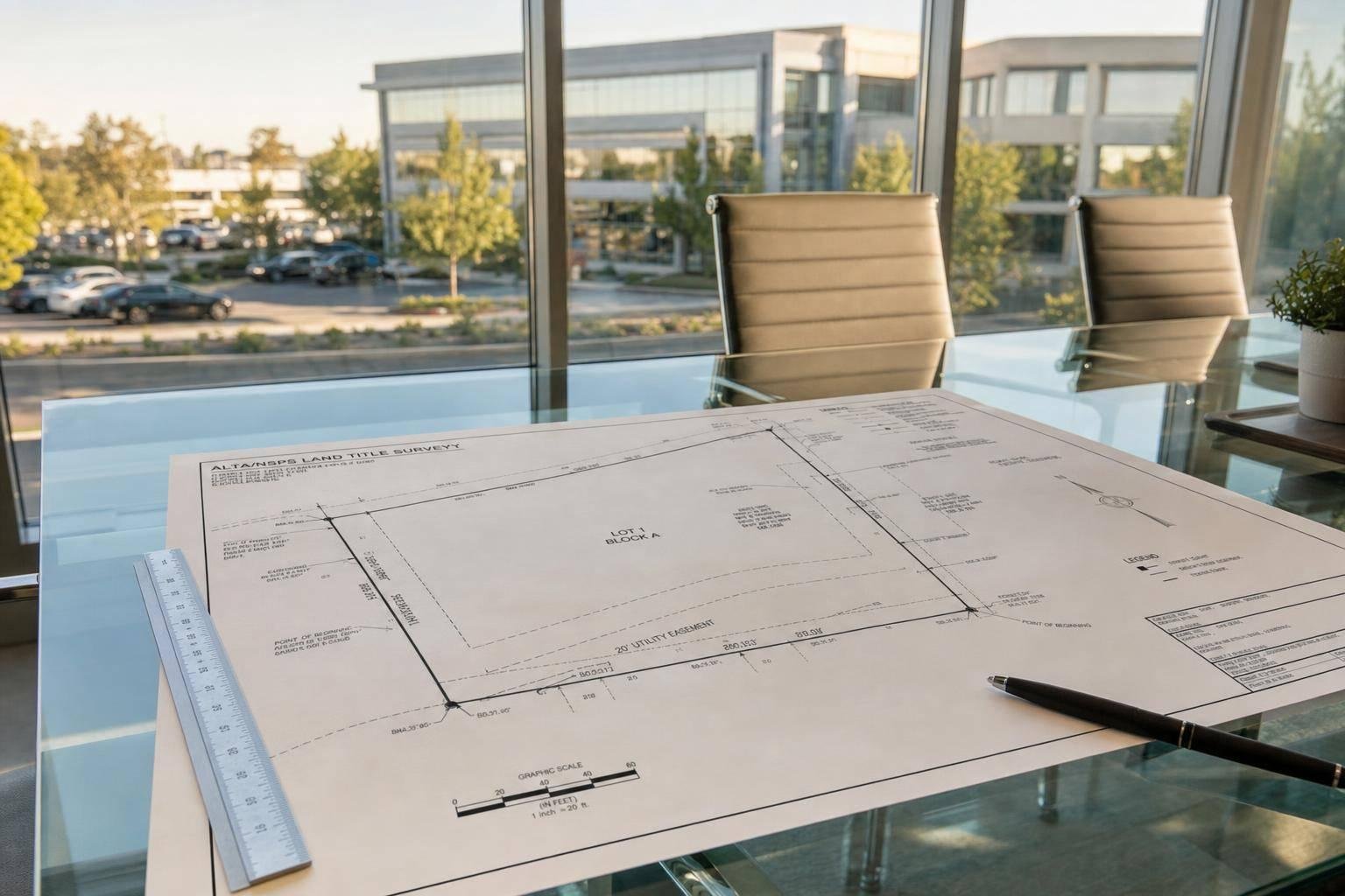
If you’re buying, lending on, or refinancing commercial property, an ALTA survey helps you spot deal risk before closing. I’d boil it down to this: it checks whether the legal record matches the site you can see, and that can affect title coverage, access, site use, and closing terms.
Here’s the short version:
- ALTA surveys tie title to field work. I use them to compare the legal description, record easements, and site conditions in one place.
- They help flag boundary and access problems early. That includes missing monuments, overlap issues, curb cuts, shared drives, and routes that exist physically but not legally.
- They map recorded easements and encroachments onto the plat. So you can see if a utility area, drainage area, or setback cuts into parking, loading, or buildable space.
- They support title insurance review. Without a current survey, a general survey exception often stays in the policy, which can leave boundary and encroachment issues outside coverage.
- The 2026 standards changed review flow. Table A Item 20 can place a short summary of observed risk conditions on the face of the survey, which helps buyers, lenders, and counsel review issues faster.
- They affect money and terms. Survey findings can lead to escrow holdbacks, price credits, cure work, named title exceptions, or changed endorsement requests.
One data point stands out: survey, inspection, and description issues made up 5.2% of title insurance claims and related losses in the cited source. That’s a small share on paper, but on one deal, even a 1-foot boundary error can change setbacks, parking count, or usable area.
If I were reviewing a CRE deal, I’d treat the ALTA survey as a working document, not a checkbox. It helps me decide what can be insured over, what must be fixed before closing, and what should be priced into the deal.
EP221 Gary Kent - Land Title Survey Standards 2026 - Section 3
sbb-itb-df8a938
Problem 1: Boundary, Legal Description, and Access Uncertainty
A deed’s legal description doesn’t always match what’s on the ground. That gap can show up as a metes-and-bounds description that doesn’t close, deed calls that overlap, or corner monuments that are gone or no longer in the right place. When that happens, you can end up with title exceptions, lender pushback, or disputes after closing. Survey, inspection, and description issues make up 5.2% of title insurance claims and related losses.[10] And even a 1-foot boundary error can affect usable area, site coverage, parking, setbacks, or room to expand.
This is where ALTA surveys come in. They connect record title to field conditions. An ALTA/NSPS survey begins with the title commitment and legal description, then checks that record against what the surveyor finds in the field, including monuments, lines of occupation, improvements, and visible encroachments.[12][2][14][17]
If monuments are missing or conflict with record evidence, the surveyor applies the evidence hierarchy and points out the uncertainty for lenders and title insurers. That matters because small mismatches can turn into big deal problems. If the survey shows a building corner, fence line, or paved area crossing the record boundary, the deal team has a chance to fix it before closing through a boundary line agreement, a lot line adjustment, or other curative action.[4][5][7][8] Once the boundary is sorted out, the next issue is access.
How ALTA Surveys Confirm Legal and Physical Access
Access is a common due diligence issue in commercial real estate. A driveway that reaches a public street does not automatically mean the parcel has legal access. Access can be shaky if it rests on an unrecorded arrangement or on an easement that doesn’t clearly benefit the property.[7][2][15]
ALTA surveys map the parts that matter on the ground, such as:
- Access points and curb cuts
- Adjoining streets and rights-of-way
- Visible shared drives, alleys, and private roads[16][17]
If the legal route and the physical route don’t match, the survey brings that issue to the surface early. That gives buyers, lenders, and counsel time to deal with it before closing. Those findings then feed straight into easement and encroachment review.
Problem 2: Hidden Easements, Encroachments, and Site Constraints
ALTA Survey vs. Basic Boundary Survey: What's the Difference?
Even when the boundary and legal access look clean, the site can still carry problems that change the deal. Recorded title doesn't show every on-site limit. Easements, rights-of-way, setback lines, and encroachments can shrink the buildable area or force fixes after closing. A utility corridor, drainage easement, or setback line might wipe out planned parking, limit where a loading dock can sit, or remove a building pad altogether. ALTA surveys show those burdens against what is actually on the ground.[19][20][21][24]
That matters because an ALTA survey doesn't just mark lines. It places recorded interests directly on the survey drawing. An ALTA/NSPS survey pulls every plottable easement, right-of-way, and recorded encumbrance from Schedule B-II of the title commitment and maps each one onto the plat with its recording reference, including book, page, and instrument number. So instead of guessing, the deal team can see exactly where a recorded burden sits on the site, including a drainage corridor that cuts through the only workable access point to a rear lot.[19][20][21][24]
Underwriters use that map to test basic deal assumptions. Parking counts can fall apart if stalls sit inside easement areas where surface work is limited. A building pad may have to move if utility or drainage easements run through the middle of the parcel. Drive aisles and loading dock plans can also run into trouble when access easements serve nearby properties. With one plat tied to title, the team can spot conflicts early enough to redesign, reprice, or negotiate curative terms before funding.[24]
How ALTA Surveys Map Easements and Recorded Encumbrances
The 2026 standards make this review much easier to scan. The 2026 ALTA/NSPS standards add Table A Item 20, an optional encroachment summary table shown on the face of the plat.[6][22][18] That's a big change because encroachments used to be easy to miss.
When Item 20 is selected, the surveyor identifies and tabulates key problem areas, such as:
- Encroachments over boundary lines
- Encroachments into rights-of-way and easements
- Encroachments into setback areas
- Undocumented cross-boundary access or use between adjoining parcels
The table is not a full inventory of every issue on the site. But it does give reviewers a direct way to find each condition on the drawing.[6][22][7][12][18]
How the 2026 Standards Improve Encroachment Review
Before 2026, encroachments were often buried in survey notes. Item 20 moves them onto the face of the plat, where people are far more likely to see them. Each entry can identify the type of improvement, the direction and approximate size of the conflict, and the legal feature affected. That setup helps underwriters, asset managers, and counsel sort out what calls for a corrective easement and what should be priced into the deal.[6][22][7][12][18][11]
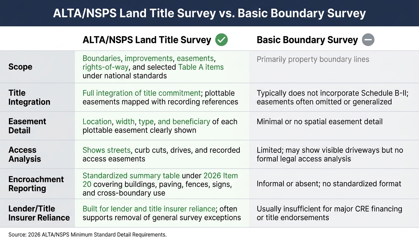
ALTA Survey vs. Basic Boundary Survey
That's the main difference between an ALTA survey and a basic boundary survey. A basic boundary survey establishes property lines, but it usually doesn't map recorded easements with recording references. It also doesn't give lenders and title insurers the kind of structured encroachment review they look for. An ALTA/NSPS Land Title Survey is built for that job, which is why lenders and title insurers rely on it.[23][9][24]
| Aspect | ALTA/NSPS Land Title Survey | Basic Boundary Survey |
|---|---|---|
| Scope | Boundaries, improvements, easements, rights-of-way, and selected Table A items under national standards | Primarily property boundary lines |
| Title Integration | Full integration of title commitment; plottable easements mapped with recording references | Typically does not incorporate Schedule B-II; easements often omitted or generalized |
| Easement Detail | Location, width, type, and beneficiary of each plottable easement clearly shown | Minimal or no spatial easement detail |
| Access Analysis | Shows streets, curb cuts, drives, and recorded access easements | Limited; may show visible driveways but no formal legal access analysis |
| Encroachment Reporting | Standardized summary table under 2026 Item 20 covering buildings, paving, fences, signs, and cross-boundary use | Informal or absent; no standardized format |
| Lender/Title Insurer Reliance | Built for lender and title insurer reliance; often supports removal of general survey exceptions | Usually insufficient for major CRE financing or title endorsements |
Problem 3: Title Insurance Gaps and Underwriting Uncertainty
Even if the survey clears up what’s happening on the ground, the title policy still decides what the buyer or lender is actually covered for.
Without a current ALTA/NSPS survey, title insurers almost always add a general survey exception to the policy. That exception cuts out coverage for matters an accurate survey would show[28][29]. In plain English, that often means no coverage for boundary disputes, encroachments, unrecorded easements, mismatches between the legal description and what’s physically occupied, and some access problems. If one of those issues shows up after closing, the buyer usually ends up paying to fix it. Broad survey exceptions also make underwriting, valuation, and securitization work harder because major site risks stay uninsured[3][35].
How ALTA Surveys Support Removal of General Survey Exceptions
A current ALTA/NSPS survey gives the title insurer something concrete to work from. Instead of relying on a blanket exception, the insurer can spot site-specific problems - like a building encroaching into a setback, a fence crossing a boundary line, or a driveway sitting partly on neighboring land - and list those items in Schedule B as named exceptions[9][3][30].
That changes the coverage picture in a big way. Problems the survey identifies can be carved out by name, while survey defects that aren’t identified may still fall within coverage. Most underwriters want the survey to be dated within 6 to 12 months, certified to the buyer, lender, and title company, and backed by the relevant Table A items before they’ll remove the general survey exception[25][26][34]. Those named exceptions then shape endorsement requests, pricing, and closing terms.
How Survey Findings Affect Endorsements, Pricing, and Deal Terms
Survey results also have a direct effect on endorsements, pricing, and closing conditions.
Say a survey shows a driveway crossing a third-party parcel with no recorded easement. The buyer may ask for an access endorsement, but the insurer might insist on a recorded access agreement before issuing it. If a structure crosses onto a neighboring parcel, that could lead to an encroachment endorsement - or the insurer may require a boundary line agreement first[31][32].
When fixes take time or the outcome is still up in the air, the deal often shifts in practical ways. Common moves include:
- escrow holdbacks
- purchase price credits
- revised closing conditions that make funding depend on specific title and survey cures[33][35]
Endorsements tied to an ALTA survey - such as ALTA 17 for access, ALTA 9.x for restrictions and encroachments, and ALTA 3.1 for zoning - usually depend on having a current survey. So when a buyer skips the survey, they’re not just limiting coverage. They’re also giving up leverage in the deal[27][28][32].
Title Coverage With and Without a Current ALTA Survey
The difference shows up most clearly when you compare the two side by side.
| Issue Type | Without Current Survey | With Current Survey |
|---|---|---|
| Boundary disputes | Broad survey exception; most boundary conflicts excluded from coverage. | General survey exception often removed; specific boundary issues listed in Schedule B; unknown boundary defects covered. |
| Encroachments | Encroachments generally excluded; limited ability to obtain encroachment endorsements. | Encroachments mapped; targeted endorsements issued; material encroachments specifically excepted. |
| Access issues | Insurer reluctant to provide access endorsements; insured access to a public road broadly excepted. | Survey confirms physical access routes; insurer issues access endorsements subject to specific exceptions. |
| Unrecorded matters / off-record conditions | Off-record conditions swept into the general survey exception and left uninsured. | Recorded and visible unrecorded easements depicted on the survey; insurer excepts them by name rather than by blanket exclusion. |
Applying ALTA Survey Findings to CRE Underwriting and Closing
How Survey Issues Flow Into Underwriting, Valuation, and Asset Plans
Once survey issues show up, the job shifts from finding them to pricing them and dealing with them in the deal.
Survey findings can change core underwriting assumptions. A utility easement might cut into rentable area. A parking easement can limit day-to-day use and affect loan sizing. Encroachments may lead to capex, like canopy changes, sign relocation, or small building additions. Flood notes can push up operating costs through insurance premiums and resilience work. The key is simple: tie each issue to a line item in the model.
This works best when the team follows the same exception-mapping process every time.
Using Survey Data in a Repeatable Review Process
Start early. Get the title commitment and ALTA survey, then match each Schedule B-II exception to the plat and flag anything listed in title but not shown on the survey.[13][36][38]
From there, place each mapped issue into a risk register based on its effect on:
- Access
- Operations
- Financing
- Future development
Legal, title, and financial teams can then sort those items into three buckets: what can be insured over, what has to be cured before closing, and what needs to be priced into the deal structure.[13][1][37]
The Fractional Analyst can translate survey findings into lender-ready underwriting, and CoreCast can track easements, setbacks, and flood notes at the asset level.[13][37]
Conclusion: The Due Diligence Problems ALTA Surveys Solve
Once the issues are mapped and priced, the closing call gets a lot clearer. In CRE underwriting and closing, ALTA surveys turn boundary, access, easement, and title questions into priced, insurable deal terms.
FAQs
When should I order an ALTA survey in a CRE deal?
Order an ALTA/NSPS Land Title Survey as soon as you get the title commitment and after the purchase agreement is signed. That timing usually gives you enough room to finish the survey and deal with any issues before closing.
This matters even more when you have a 30–45 day due diligence period. Survey problems often show up in the first couple of weeks, and they can affect lender approval, title insurance coverage or endorsements, and the final deal terms.
Who relies on the ALTA survey at closing?
In commercial real estate deals, lenders, buyers, sellers, title companies, and attorneys all lean on the ALTA/NSPS survey. Lenders use it when deciding whether to approve a loan, and title companies use it to check exceptions and issue insurance policies.
For buyers and investors, the survey confirms boundaries, easements, and possible encroachments. That matters because it helps shape negotiations and gives them a clearer view of risk.
What Table A items should I request for my property?
Request the ALTA/NSPS Table A optional items that fit your due diligence risks.
Common picks include:
- Item 11: underground utility documentation and visible utility easements
- Item 19: offsite easements mapped to the same detail level
- Item 20: an encroachment summary table for newer or more complex deals
You may also want topography, flood zone data, utility locations, setback and height restrictions, and building dimensions if those details affect boundaries, easements, access, or development planning.